xxxxxThe British explorer Charles Sturt made two gruelling expeditions to explore the river system of S.E. Australia, starting in 1828. He discovered the Murray and the Darling, and followed the Murray down stream, reaching the south coast near Adelaide in 1830. These findings opened up extensive areas for future development across New South Wales and South Australia, and enabled the founding of an entirely new colony. A British army officer, he returned to England in 1832, and it was there that he wrote his Two Expeditions into the Interior of Southern Australia, 1828-
CHARLES STURT 1795 -
(G3b, G3c, G4, W4, Va, Vb)
Acknowledgements
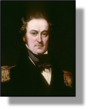
Sturt: detail, by the English portrait painter John Michael Crossland (1800-
xxxxxAs we have seen, the English navigator Matthew Flinders circumnavigated the island of Tasmania (then Van Diemen’s Land) with his fellow countryman George Bass in 1798. He then went on to sail around the entire continent of Australia, completing his journey in 1803, and charting the southern and eastern coasts en route. But if, by then, the coastline of Terra Australis was fairly well known, the interior of this vast new land was certainly not. The Great Dividing Range which ran down the east coast had seen to that. It was not until 1813, in fact, that the Australian explorer Gregory Blaxland managed to cross the Blue Mountains -
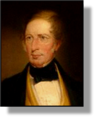
xxxxxIt was left to the British explorer Charles Sturt (illustrated) to prove them wrong, but not in the short term. At first, in the course of two gruelling expeditions, constantly delayed by illness and water shortages, he explored the river system of south-
Including:
Exploration in Central
Africa and the Antarctic
and Arctic Regions

G4-
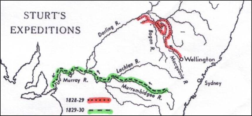
xxxxxAlthough Sturt was to make a further expedition of importance some years later, journeying into the centre of this huge continent, his discovery of the river system of south-
xxxxxThough he is universally known as an explorer, Charles Sturt was, in fact, a regular serving officer in the British army. He was born in India and, after being educated in England, joined the army at the age of 18. After seeing service in Spain, Canada, France and Ireland, he was sent to Australia in 1827 as military secretary to the governor of South Wales, and it was then that he began his role as an explorer. However, the expeditions he embarked on the following year, though highly successful and useful in themselves, put a great strain on his health, and in 1832 he returned to England to recuperate. It was there that, over the next two years, he produced and published his Two Expeditions into the Interior of Southern Australia, 1828-
xxxxxSturt returned to Australia in 1834, and it was during this second period of service, as we shall see, that in 1844 he led an expedition from Adelaide northwards into the interior of the continent and in 1846 (Va) proved without doubt that the heart of Australia was not a huge inland sea but a vast, inhospitable desert. And by this time others -
 xxxxxButxexploration during the reign of George IV was by no means confined to Australia. In 1822, for example, three British explorers, Hugh Clapperton (1788-
xxxxxClapperton and Oudney then continued to explore further west, but Oudney died of a fever on reaching Katagum in northern Nigeria. Clappertonxvisited a number of towns, including Kano and Sokoto, before returning home in 1825. Later that year, accompanied by his servant Richard Lander, he returned to Nigeria, but died near to Sokoto in 1827. It was the Englishman Richard Lander (1804-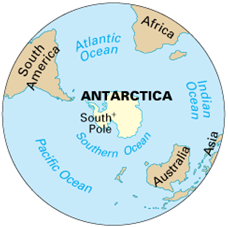 eventually reaching the river’s huge delta in 1830.
xxxxxMeanwhile, in a climate poles apart from central Africa, the Russian naval officer and explorer Fabian Gottlieb von Bellingshausen (1778-
xxxxxThexfirst recorded landing was made the following month by men from the American sealer Cecilia, under the command of Captain John Davis (b.1784). They stayed on land for about an hour. Andxtwo years later the British seal hunter and explorer James Weddell (1787-
xxxxxLater, as we shall see (1831 W4), three major expeditions to the region took place in the late 1830s, one led by the English explorer James Clark Ross (known earlier for his discoveries in the Arctic), one by the French navigator Jules Dumont d’Urville (the man who negotiated the purchase of  the Greek sculpture the Venus de Milo for the French government), and a third by the U.S. naval officer Charles Wilkes, who later gained fame in the “Trent Affair” at the beginning of the American Civil War.
 xxxxxInxthe Arctic, in the meantime, the English explorer William Parry (illustrated), travelling across the drift ice from Spitsbergen in 1827, reached 82.45’N, beating the record set by the English whaler and amateur scientist William Scoresby in 1806. He discovered the islands of Melville, Cornwallis and Bathurst. Then in 1829 the Scottish explorer John Ross led an expedition to discover the elusive Northwest Passage. Its members only just escaped with their lives, but, as we shall see, it was during that expedition, in 1831 (W4), that his nephew James Clark Ross, travelling by sledge, discovered the north magnetic pole.